
KANNIYAKUMARI
Kanyakumari also known as Kanniyakumari. formerly known as Cape Comorin, is a town in Kanyakumari District in the state of Tamil Nadu in India. The name comes from the Devi Kanya Kumari Temple in the region. It is the southernmost tip of peninsular(தீபகற்பம்) India. Kanyakumari town is the southern tip of the Cardamom Hills, an extension of theWestern Ghats range. The nearest town is Nagercoil, the administrative headquarters of Kanyakumari District, 22 km (14 mi) away. Kanyakumari has been a town since Sangam period and is a popular tourist destination.
HISTORY
Ptolemy's geography describes commercial relations between western India and Alexandria, the chief eastern emporium of theRoman Empire. He identified Kanyakumari along with the Gulf of Mannar as a center for pearl fishery. He also identifies Korkai, a place to the east of Kanyakumari, as an emporium of pearl trade.
Another ancient Greek book, the Periplus of the Erythraean Sea, contains sailing directions for merchants from the Red Sea to theIndus and Malabar, and even indicates that the coast from Barygaza (Baroch) had a general southward direction down to and far beyond Cape Komari.
Kanyakumari District consists of those parts known locally as Nanjil Nadu and Idai Nadu. The names of the villages of the district such as Azhagiapaandipuram, Bhoothapandy, Cholapuram and Kulasekaram reveal that these places were governed by several rulers at different periods of time.]Nanjilnadu was under the rule of Pandiyas till the early 10th century and then under Cheras.
The Kalkulam and Vilavancode taluks were under the rule of the Chera Dynasty. When the power of Chola declined due to the rise of Hoysalas and western Chalukyas, the Venad (Travancore) Chieftains (descendants of the central Chera family) took advantage of the situation and gradually established their hold on considerable areas in Nanjilnadu. Veera Kerala Varma, one such chieftain, styled himself as "Nanjil Kuravan". The annexation commenced by Veera Kerala Varma was to a large extent continued by his successors and completed by AD 1115.
For about four centuries, the Venad was ruled by powerful kings who were consistently making incursions into the Pandian territories. As a result, Vijayanagar kings proceeded against Venad. In 1609 Kanyakumari fell into the hands of Viswanatha Nayak of Madurai. Consequent on this, there was no serious threat to Nanjilnadu until 1634. During the regime of Ravi Varma and Marthanda Varma, Venad was disturbed by the internal strife.
Sanda Sahib of Arcot took advantage of this situation and attacked Nanjilnadu. Although Marthanda Varma was victorious in the battle of Colachel and defeated the Dutch armouries who helped the local feudatories, he could not cope with the threat from Sanda Sahib, which forced him to withdraw from the battlefield. After Marthanda Varma, Venad had weak rulers and as a result there was frequent interference by the British (who knew it as Cape Comorin) whose control was completely established over Venad and continued until 1947. From 1947 to 1956, it was under the personal rule of Maharaja of Travancore. During the period between 1956–1961, the administrative system has fallen in line with that of other districts in Tamil Nadu.
MODERN HISTORY
Kanyakumari has been a great centre for art and religion for centuries. It was also an area of great trade and commerce. It was ruled by the Cholas, the Cheras, the Pandyas and the Nayaks. The architectural beauty of the temples in the area are the works of these rulers. Later Kanyakumari became part of the Venad kingdom with its capital at Quilon. The king of Venad, Anizham Thirunal Marthanda Varma, established Travancore by extending his domain further north up to Azhva, during his reign from 1729 to 1758. By this, the present Kanyakumari District came to be known as Southern Travancore. In 1741, Maharaja Marthanda Varma defeated the Dutch East India Company at the famous Battle of Colachel.
Kanyakumari was under the rule of the Pandyan Kings till the downfall of Pandyas, and later by kings of Travancore under the overall suzerainty of the British (as "Cape Comorin") until 1947, when India became independent. Travancore joined the independent Indian Union in 1947. The reign of the Travancore royals came to an end.
In 1949, Kanyakumari became part of the reconstituted Travancore-Cochin State. Around this time, a popular agitation by the Tamil-speaking people of the district for the amalgamation of Kanyakumari District with Tamil Nadu intensified under the leadership of Marshal Nesamony. Kumari Thanthai Marshal Nesamony was instrumental in the merger of Kanyakumari district with Tamil Nadu (then known as Madras State) in 1956 during the linguistic reorganisation of states.
LOCATION &WEATHER
Kanyakumari is located at 8.08°N 77.57°E. It has an average elevation of 300 metre. Contrary to the popular (and sensational) belief that Kanyakumari lies at the meeting point of three bodies of water, it borders only one: the Laccadive Sea to the south west, south, and to the southeast. It is the confluence of the Western Coastal Plains and Eastern Coastal Plains.It is located at the southern tip and southernmost point of the Indian Subcontinent. However, the southernmost point of the Republic of India is at Indira Point on Great Nicobar Island, at 6°45’10″N and 93°49’36″E.Kanyakumari is used geographically to define southern end of the Coromandel Coast region.
TOURISM
Thiruvalluvar Statue
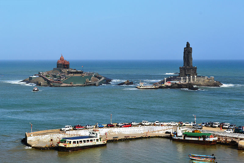
 The Thiruvalluvar Statue has a height of 95 feet (29 m) and tands upon a 38 foot (11.5 m) pedestal that represents the 38 chapters of "virtue" in the Thirukkural. The statue standing on the pedestal represents "wealth" and "pleasures", signifying that wealth and love be earned and enjoyed on the foundation of solid virtue.The combined height of the statue and pedestal is 133 feet (40.5 m), denoting the 133 chapters in the Thirukkural. It has a total weight of 7000 tons.The statue, with its slight bend around the waist is reminiscent of a dancing pose of the ancient Indian deities like Nataraja. It was sculpted by the Indian sculptor Dr. V. Ganapati Sthapati, who also created the Iraivan Temple. Its opening ceremony was on 1 January 2000. The monument was hit by the Indian Ocean Tsunami on 26 December 2004
Vivekananda Rock Memorial
 The Vivekananda Rock Memorial is a popular tourist monument in Vavathurai, Kanyakumari, India. The memorial stands on one of two rocks located about 500 metres east of the mainland of Vavathurai, India's southernmost tip. It was built in 1970 in honour of Swami Vivekanandawho is said to have attained enlightenment on the rock.[1] According to local legends, it was on this rock that Goddess Kumari performed austerity. A meditation hall (Dhyana Mandapam) is also attached to the memorial for visitors to meditate. The design of the mandapa incorporates different styles of temple architecture from all over India. It houses a statue of Vivekananda. The rocks are surrounded by theLaccadive Sea. The memorial consists of two main structures, the Vivekananda Mandapam and the Shripada Mandapam.
Gandhi Memorial Mandapam
 The Gandhi Memorial Mandapam has been built on the spot where the urn containing the Mahatma's ashes was kept for public viewing before immersion. Resembling central Indian Hindu temples in form, the memorial was designed in such a way that on Mahatma Gandhi's birthday, 2 October, the first rays of the sun fall on the exact place where his ashes were kept.
Tsunami memory park
 Near Kanyakumari's southern shore stands a monument to the memory of those who died in the 2004 Indian Ocean earthquake and tsunami, an underwater megathrust earthquake that claimed around 280 000 lives in many countries, including India, Sri Lanka, Somalia, Thailand, Maldives and Indonesia. People from places near and far visit this monument to pay homage to all those who lost their lives.
Bhagavathy Amman Temple

Ayya Vaikundar Nizhal Thanal

Kamarajar Mani Mantapa Monument

Padmanabhapuram Palace
 Padmanabhapuram Palace is located in at Padmanabhapuram Fort, in Padmanabhapuram, Kanyakumari District, Tamil Nadu, India. Padmanabhapuram is the former capital city of the erstwhile Hindu kingdom of Travancore. It is about 20km from Nagercoil, and about 50km from Thiruvananthapuram, Kerala. The palace is complex inside with an old granite fortress around four kilometers long. The palace is located at the foot of the Veli Hills, which form a part of the Western Ghats. The river Valli flows nearby.
St. Xavier's Church, Kottar
 St. Xavier Church is a Roman Catholic Latin Rite shrine located at Kottar, Nagercoil in Kanyakumari district of Tamil Nadu state, India. While Saint Xavier was doing missionary work at Kottar and its neighbourhood, he averted an invasion of Padagas with the help of his cross alone and thus protected the people of Venad kingdom from that attack which was appreciated by the king, Unni Kerala Varma, who became closer to the priest and befriended him from then on. In recognition of Xavier’s services, the king allotted him a piece of land to construct a Catholic church, as a gesture of goodwill, as per the church records. There was already a small church, in the same place where St. Xavier’s church stands at present, dedicated to Mary the Mother of God, since AD 1544 .[1] Church records indicate that St. Xavier Church was built in 1600. In 1865, the Shrine of Mary was renovated and enlarged. In 1930, the church was raised to the status of a cathedral. The annual festival is celebrated during November – December, lasting for 10 days
Perunchani Dam
 Perunchani Dam is an irrigation dam at Perunchani, in Kalkulam Taluk, Kanyakumari District, in the state of Tamil Nadu, India. It is one of the dams of the Kodayar Irrigation System.[1] As there was water deficiency in the Kodayar Irrigation System, Perunchani Dam was constructed in December 1952 to store flood water of the Paralayar River as an extension. It was built about 1 km (0.62 mi) upstream of the Puthen dam on the Paralayar River. The irrigation system became operational on 2 September 1953. It feeds the left bank irrigation canal system of the Puthen dam, which is the terminal structure of the system.
Pechiparai Reservoir
 Pechiparai Reservoir is a reservoir located 43 kilometres (27 mi) from the town of Nagercoil, near the village of Pechiparai inKanyakumari District, Tamil Nadu, India.
The reservoir was formed by the construction of the Pechiparai Dam, which was built across the Kodayar River about 1 mi (1.6 km) below the confluence of the Kallar, Chittar and Kuttiyar tributaries. It was built during the period 1897 - 1906 by the European engineer, Mr. Minchin,(called as mookanthurai by the local people) during the reign of the Travancore Maharaja Moolam Thirunal.
The original cost of construction of the dam was Indian Rupees 26.1 Lakhs (in the late 19th century). The catchment area of the reservoir is 207.19 km2 (80.00 sq mi), and the depth is 14.63 m (48.0 ft). The dam is a straight gravity type masonry dam 425.5 m (1,396 ft) long and 120.7 m (396 ft) high above the deepest foundation. There is no inspection gallery.
The water from the reservoir is used for both irrigation of crops and for drinking purposes, which has led to conflict between farmers who want to use all the water for their crops, and local authorities, who don't have another place to draw drinking water from, for supply to the urban areas. The dam is surrounded by hills of the Western Ghats.
ulakkai aruvi
 Ulakkai Aruvi is a beautiful falls on Pazhayar, close to its origin. It is so named as it resembles a wooden utensil in the shape of hour glass. Left Keeripara in our WagonR with Senthil, an estate supervisor based at Keeripara, who is very familiar with the sector. Hit Thadikarakonam and took left for Azhagiapandiapuram along SH 45 of Tamil Nadu. Short stop at Azhagiapandiapuram for gathering light eatables and entered the narrow road to the left, directed towards the Western Ghats is the route from trivandrum.You can reach this beautiful place by bus also. Ulakai Aruvi is situated about 40 km north of kanyakumari.
 SANGUTHURAI
 Sanguthurai is a small village in Kanyakumari district, Tamil Nadu, India, near Nagercoil. Sanguthurai beach is situated about 9 km from Nagercoil town. Sanguthurai beach is a sandy beach and it has huge white pillar with black conch built during King Chola period. From this beach you can see Thiruvalluvar statue and Vivekananda rock in a long view. Backwater view in Sanguthurai beach is really looks beautiful.
Sanguthurai Beach is very calm and better place for people enjoy loneliness. Sanguthurai beach welcomes you with sangu statue, and a sea tower, which gives you a long shot view of the beach and the entire area surrounded by a coconut tree.
MUKKADAL DAM
 Mukkadal dam is built across the Vambaru River in the state of Tamil Nadu in southern India, 10 km (6.2 mi) from town of Nagercoil. It is a scenic place, favored as a picnic location among local residents. It was built by Sree Chithira Thirunal Balarama Varma in 1945, the King of Travancore. The dam is constructed of clay and granite stones. The depth of water behind the dam is approximately 100 ft (30 m). The reservoir supplies water for the town of Nagercoil.
The mountain consists of soaring and lofty trees of Mesua ferrea, Bischofia javanica, Vitex Altissima to smaller trees of Dillinia species of festooning climber, shrubs, valuable herbs, variety of orchids, two types of canes and many indigenous palms and cycads. The important timbers are teak, rosewood, vengai. Various types of forest products like bamboos, reeds, canes, soft wood tamarind, lemon grass, rubber, coconut, areca nut, kadukkai, cinnamon bark, nelli, cardamom, mango, lemon varieties, jack fruit, and many medicinal plants of high value which are harvested here. The mountain range is near the end point of Western Ghats.
No comments:
Post a Comment